Remember Every Step From Your Photo Trips—Learn to Work With Track Logs
Having your photo files tagged with GPS coordinates is very practical. Not only do they let you know where exactly you took each photo, but also, using a track log you can see the path you took on your trip and how your photos lead across the map. What’s more, you don’t even have to have built-in GPS in your camera.
All you need to get detailed route information is a mobile phone and an app that records GPS data and saves a data file—a track log—based on it. Then you just load in that file in Zoner Studio, and it GPS-tags your photos automatically.
Set Your Clock Precisely
Zoner Studio uses track logs to GPS-tag photos based on the exact times when they were taken. The time on your phone is usually set precisely via the Internet. But you’ll want to check to see if your camera clock is set correctly.
Record the Route
To record the route, use a GPS data logger, or a phone app (such as e.g. Geo Tracker) that can save a track log as a .gpx file. Just turn on your device before heading out on your trip, and it will record your position as you go.
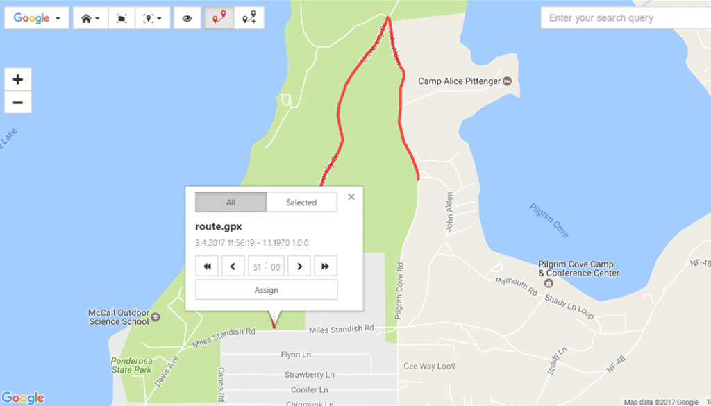
Assign the Track Log to the Photos
Open the folder with the photos in the Manager, select the photos, and click the Load Track Log icon in the right panel. Find the exported .gpx file you’ve saved to your computer, and click Open.

Your route is shown on the map, along with a tool for assigning GPS data to your photos. If you discover that the time in your camera wasn’t set correctly, here you can shift it manually to make up for the difference between the times on your phone and on your camera.

Click Assign, and the GPS data will be written to the photo files’ own EXIF data.
View Your Trip on a Variety of Maps
Used together, a track log and Zoner Studio help you to clearly see the route you took throughout your trip. Zoner Studio also offers a variety of different maps, including aerial and even hiking maps. In every place where you’ve taken a picture, a map pin will appear—either empty, or with a number showing how many pictures were taken in that spot. Hover the mouse over a map pin to see a photo preview. Click the pin to select the picture or pictures that it represents.

A Whole New Dimension for Memories and Presentations
Photos always come in handy when you’re looking back at a wonderful vacation—or telling stories about it. And when you spice them up with a map showing the route you followed while taking them, that’s a great way to remember… or to captivate your audience.